![[move]worcester](https://substackcdn.com/image/fetch/$s_!Fywr!,w_120,h_120,c_fill,f_webp,q_auto:good,fl_progressive:steep/https%3A%2F%2Fsubstack-post-media.s3.amazonaws.com%2Fpublic%2Fimages%2Fc2d0ae5a-1209-4df0-bd50-f6a02caca397_1280x1280.png)
Park Ave needs a road diet
I see your MS Paint and raise you a code compliant ROW redesign!

I recently came across a Reddit post that reimagined a new streetscape for Park Ave, complete with a road diet, two-way center turning lane, and bike lanes:
 Park Ave sucks to travel on.")
Overall, I think it’s a great idea (and a solid execution for MS Paint), and it got me thinking about what a Park Ave road diet would look like. Fortunately, I am a bit more qualified to answer that question than most: my work has made me quite intimate with the MUTCD, and my interest in roadway design in Massachusetts means I’m also familiar with the MassDOT Separated Bike Lane Planning & Design Guide. I’m not a licensed transportation engineer, though, so don’t take this as gospel!
The Problems
In order to come up with a good solution, we must map out the existing problems. Here are some of Park Ave’s biggest issues, taken from my own experience walking and driving down the road along with other input on the aforementioned Reddit post:
Two lanes per direction, encouraging unsafe driving speeds and risky merges.
No dedicated left-turn lanes, blocking the left travel lane for through traffic.
No bike infrastructure, making it uncomfortable, stressful, and unsafe for cyclists.
No bus infrastructure, making it harder for riders to ride the bus effectively.
No marked parking spaces, causing sloppy parking that obstructs the travel lanes.
Long, unprotected crosswalks, endangering pedestrians crossing the street.
Stacked together, these problems make Park Ave frustrating and unsafe for everyone.
The Fixes
Fortunately, there are specific design choices to address each of these problems:
The excess lanes can be addressed by removing a travel lane in each direction and reducing the width of the remaining lane.
The lack of dedicated turning lanes can be addressed by adding a center two-way left-turn lane.
The bike and bus infrastructure can be addressed by building separated bike lanes and bus shelters.
The unmarked parking spaces can be addressed by painting dedicated metered parking spots.
The dangerous crossings can be addressed by building pedestrian refuge islands and reducing the number of travel lanes.
But it feels a bit naive to just slap all of these things in a slick infographic and ship it off to City Hall. So, I’ll take a second to dive into each design choice and see if it’s the right fit for Park Ave.
Reducing travel lanes
The first step to reducing travel lanes is determining if the reduced lanes can handle the existing traffic. The most applicable statistic is a road’s annual average daily traffic (AADT for all the traffic heads out there), which is a broad metric for how much daily traffic a road gets. While I have some issues with taking AADT as gospel in roadway design, it’s a good place to start.
MassDOT’s most recent vehicle count pegs Park Ave with an AADT of around 19,900. As a rule of thumb, one travel lane can handle 10,000 vehicles daily, meaning a two-way road can accommodate 20,000. This puts Park Ave at the upper limit for a two-way road, meaning a road diet is tough, but possible.
Sloppy parking and no left turn lanes means cars today have to frequently weave from the left to the right lane, turning Park Ave’s existing two lanes per direction into effectively one lane per direction. And while there is some congestion on Park Ave, it can get better with smart traffic control. So, with all this considered, I think Park Ave can reasonably handle a road diet, especially with a two-way left turn lane. One point on the board!
Dedicated turning lanes
You’ve heard me talk about a two-way left turn lane, but what is that? You’ve probably seen it before: one middle lane is dedicated to left turns for both directions at once. This means that cars traveling in either direction can move over into the middle lane to wait for a break in traffic, allowing cars behind them to keep going. Here’s a neat graphic to illustrate, courtesy of a WikiHow article (no idea they still made those!):

At intersections, these two-way left turn lanes can turn into dedicated left turn lanes to give cars a space to queue out of the through-traffic lane. And while this does restrict left turns beyond the intersection in the other direction, I think that’s a fine tradeoff. As long as we remove a travel lane in each direction, we can accommodate a center turning lane no problem. Two points!
No bike infrastructure
This is one of the tougher ones. There are many bad ways to make a bike lane, and the good ones often take more space than you expect. While I would love to add in bike lanes and keep both parking lanes, these bike lanes would be unseparated, dangerous, and unpopular. I want to do it the right way with separated bike lanes, which means sacrificing a parking lane.
But can we remove a lane of parking? Looking at historical aerial imagery of Park Ave, I did not see a single instance where parking on a block was over 30% filled, which suggests removing a lane of parking isn’t a big deal. Most places on the block have off-street parking, after all.
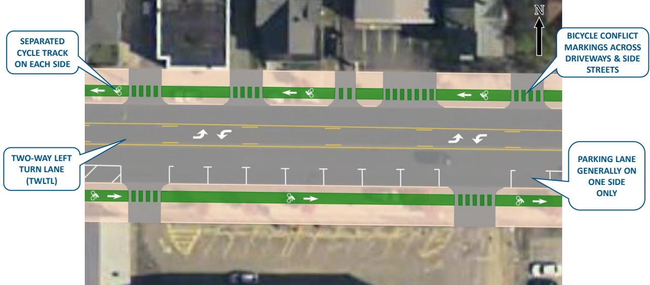
From curb to curb, Park Ave is 55 feet wide, which means we have 55 feet to fit two travel lanes, a turning lane, a parking lane, and two bike lanes with medians to separate them from car traffic.
Let’s first design each lane to its absolute minimum to see if it can all fit. For this kind of road—an urban minor arterial to my best judgement—travel and turning lanes shouldn’t be less than ten feet, and parking lanes shouldn’t be less than seven. That means all vehicle travel and parking comes out to 37 feet. That gives nine feet on each side for the separated bike lanes.
According to the MassDOT Separated Bike Lane Planning & Design Guide, separated bike lanes should be at least five feet wide and separated from the road by at least two feet. This gives us two more feet to work with on either side. I would give the extra two feet on each side to the bike lane medians, expanding them to four feet. This would make the corridor look something like this:
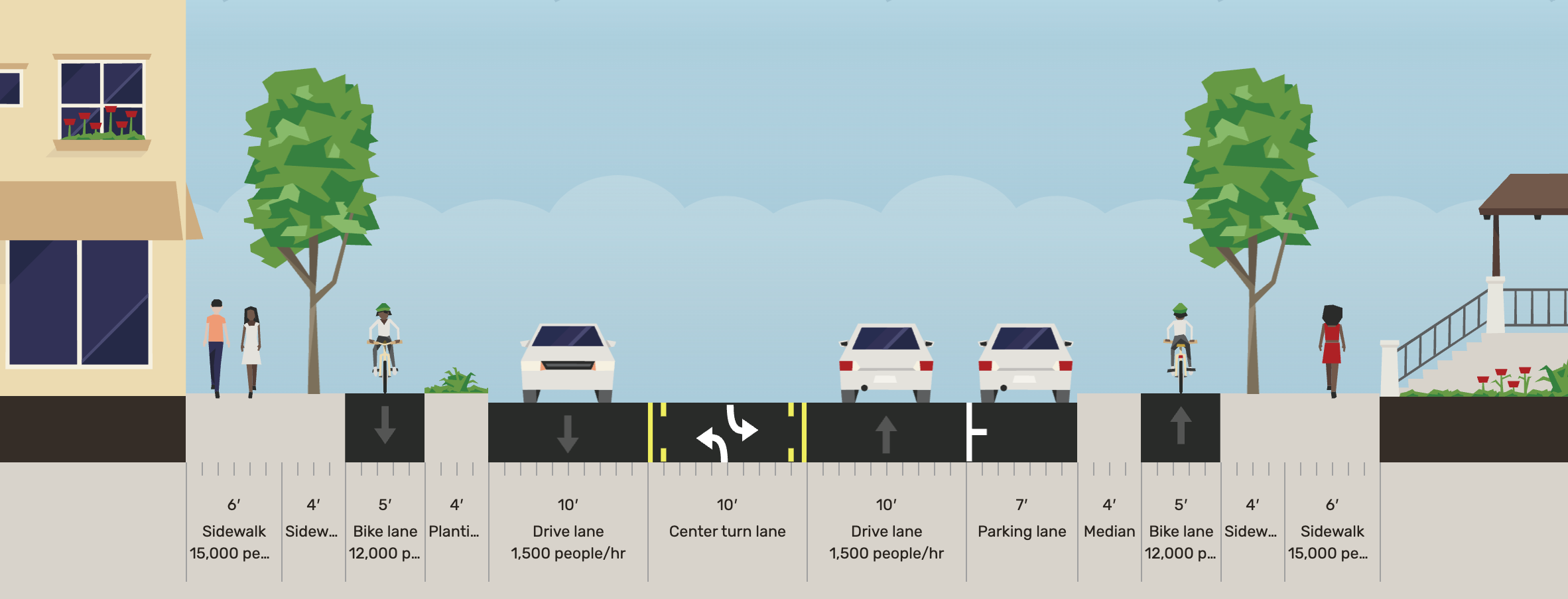
While this design looks reasonable, there’s one problem: daylighting. If you’ve driven down Park Ave, you’ll notice that it has a surprising amount of driveways and parking lots. On some sections, it’s so bad that there’s more driveway than curb. On roads with separated bike lanes and no street parking, this is fine—cars have a full view of any cyclist that’s riding down the road when turning into a driveway or parking lot. But when you have a row of parked cars obstructing a car’s view of a cyclist, the cyclist can easily get T-boned by a car making a right turn.
To fix this, the parking lanes get “daylighted,” meaning the parking spots closest to the driveway (or parking lot, or intersection) are removed so drivers have a clear view of the bicycle lane. Twenty feet of daylighting on either side is the accepted standard. But on a street like Park Ave that sees driveways and parking lot entrances every sixty feet, daylighting means that less than a third of that parking lane is being used.
There are two ways to fix this. The first is to limit the number of driveways and parking lot entrances along the corridor. For many of Park Ave’s existing buildings, this is too unrealistic. The second is to move the parking lots somewhere else entirely, either to the back of the lot or to a larger municipal lot a short walk away.
I’m on board with this. Park Ave looks pretty dumpy for a main drag, and I think this is in part because the street has no density. Instead of one building leading right into the other without any gaps—take parts of Highland and downtown for example—they are all separated by nasty lots and driveways.
If developers were instead encouraged to build right up to the property line, not only would more street parking spots fit on the block, Park Ave would turn into a space much more pleasant to be in.
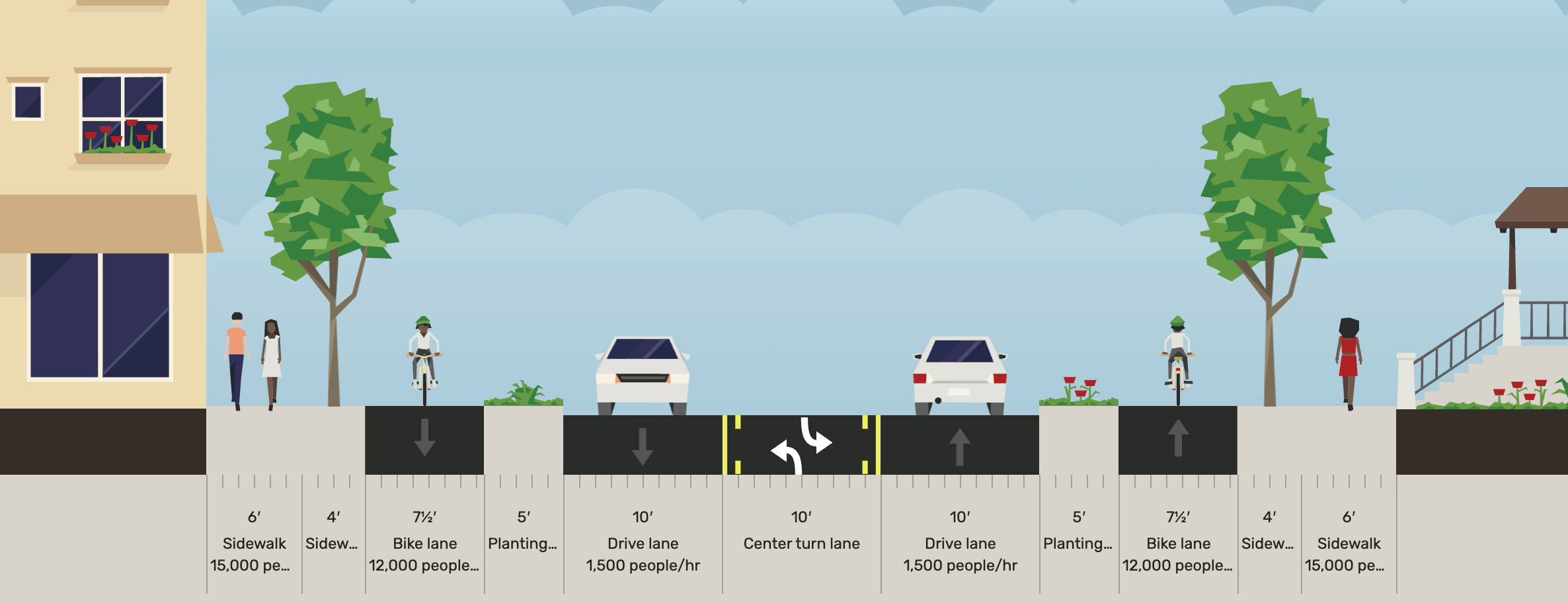
But there is also a case to be made to get rid of that second parking lane, especially if cars had other lots nearby. We would have seven more feet to play around with, meaning we can expand the medians to five feet and the bike lanes to a beefy seven and a half feet!
Either way, it’s entirely possible to add protected bike lanes without sacrificing the experience of walkers or drivers. Three-nil for a road diet!
No bus infrastructure
With bus infrastructure comes a big dilemma. I can see the potential of Park Ave becoming a popular corridor for radial bus trips, so to me it’s worth offering something more than signposts for riders. But while we have enough space for separated bike lanes and enough space for dedicated bus lanes, we don’t have enough space for both. Choosing one or the other depends on how the bike or bus network is being built out as a whole.
A deep dive into the merits of bike lanes versus bus lanes would add some helpful nuance to this discussion, but it’s a topic for another day. If you want more, Andy Boenau offers a potent case for prioritizing bus infrastructure. For now, I assume that Worcester is instead looking to build out its network of interconnected separated bike lanes.
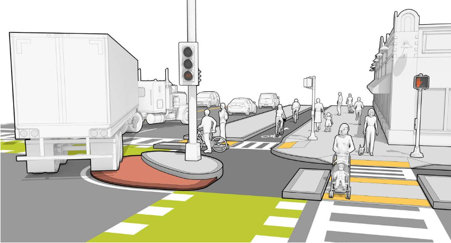
Fortunately, we can still incorporate some better bus infrastructure into the existing bike-forward design. The MassDOT guide from earlier has specific design provisions for integrating bus stops and shelters into streets with protected bike lanes. The guide permits reducing the bike lane to four feet and removing the median between the bike lane and the sidewalk. The median can then expand to become a waiting area. At a bus stop, the street would resemble something like this:
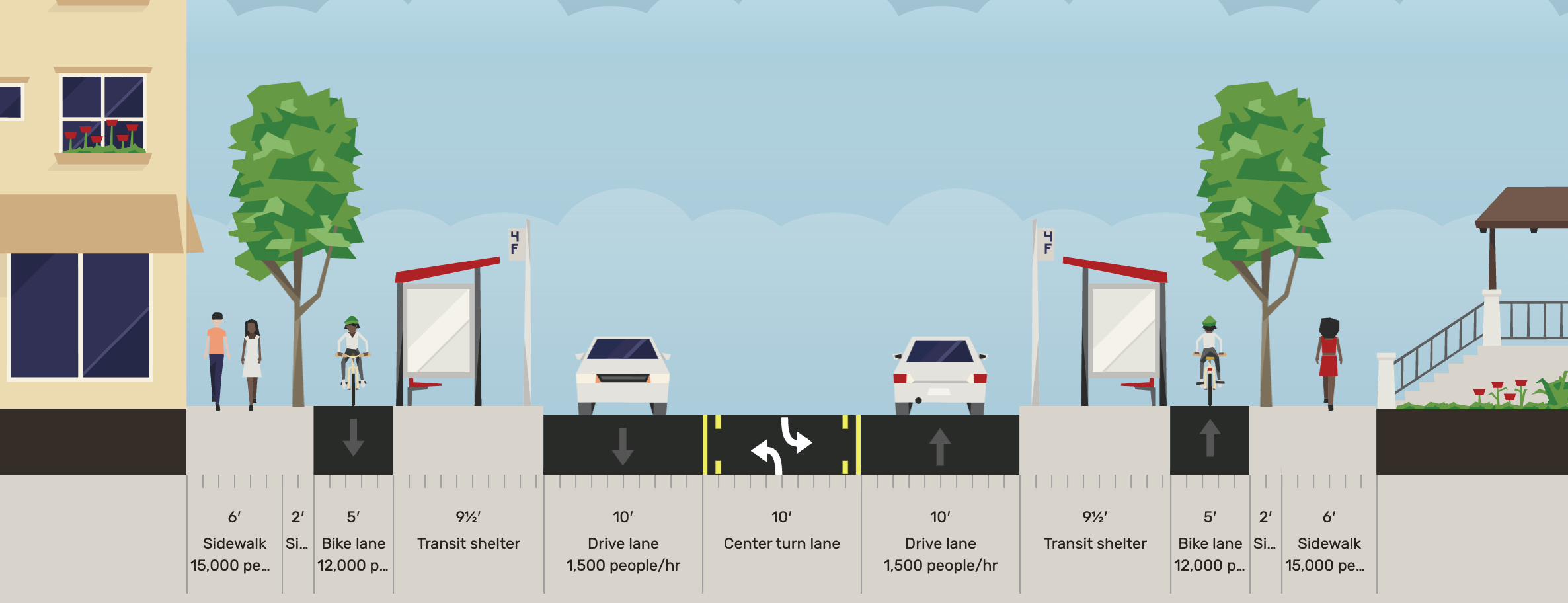
There we go—bus shelters with room to spare. Cars could also use the center turn lane to overtake the bus while it’s stopped. Another point on the board.
No marked parking spaces
Easy one. All we have to do when rebuilding the roadway is put some paint down. I’ll give this a pity point.
Long, unprotected crosswalks
At its worst, pedestrians must walk 71 feet to get to the other side of the road. With the separated bike lane configuration, pedestrians walk thirty feet at most. Of course, they must also cross the bike lanes, but because of the median, they have a refuge island to wait at between the bike and car lanes. Our final point!
Is this all possible?
We were able to implement all the proposed fixes with room to spare. But does something like this have any chance of being made in Worcester? Actually, yes it does!
In 2021, the city prioritized Chandler St. for a corridor redesign. While the project is not under construction yet, the preliminary designs quite closely resemble my proposed Park Ave redesign, down to the center turn lane, the one parking lane, bus shelters, and separated bike lanes.
This presents a great opportunity to make a beautiful Dutch-style protected intersection at Park and Chandler, provided separated bike lanes are implemented on both roads. Combining the linear connector of Chandler St with the radial connector of Park Ave can make a powerful network for safe and comfortable bike trips through the city.
There it is—a Park Ave that accommodates all kinds of movement, not just cars. If you want to take a crack at redesigning a street in Worcester, Andy Boenau has a good article that explains how with a website called Streetmix.
One more note. There is a lot more to consider when implementing a road diet that is out of the scope of this article: there’s peak-hour congestion, diversion, illegal parking, and emergency vehicles, not to mention funding, policy, and NIMBY opposition. This is meant to be an exploration of alternate street design, not a prescriptive blueprint.
I would love to hear what ideas you all have: do you think buses should be prioritized instead of bikes along this corridor? Do you think EV charging should be considered? Have any other corridors you would like to put on a road diet? Let me know! There are many ways to fix a street depending on what’s needed along the corridor, so the more people who throw their hat into the ring, the better.
These are such great ideas! One (myself) could probably throw together a whole vision of Park Ave as a transit corridor, but I do see great value in the expansion of cycling infrastructure along that corridor. It's in dire need of some change in 2025.